Our Icy Past
Adapted from Mass Audubon
Continent-wide glaciers are called ice sheets. The most recent one built up starting perhaps 100,000 years ago and reached its maximum thickness over Massachusetts between about 22,000 and 14,000 years ago. Some land was scraped away right down to the bedrock, whereas other land was built up from the soil that was removed. When the glacier melted away, plants and animals returned from the warmer ice-free south. Some slow-moving life still hasn’t reappeared. For example, the glaciers destroyed native earthworms—all our earthworms are imports from Europe.
Glaciers
The ice sheet over Massachusetts was up to two miles thick. As it moved forward, and then retreated, it created well-known features like Cape Cod, the Boston Harbor Islands, Walden Pond, Plymouth Rock, and many other kettle holes, drumlins, and eskers.
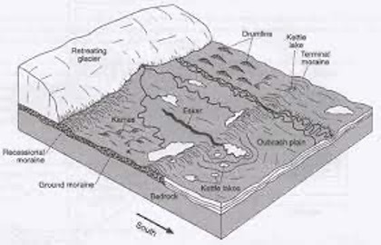
Massive sheets of ice in motion leave behind plenty of evidence. Here are five of the many glacial features you can see on Groton’s trails:
Glacial till
New England’s famous stonewalls are made of rocks that farmers removed from fields so they could plow. They’re part of a layer of unsorted rubble called glacial till that was left behind as the glacier scoured soil and bedrock. Find stonewalls as you hike many of our trails including Wharton Plantation and Gamlin Crystal Springs.
Erratics
Glaciers also carry big boulders and drop them “erratically” in improbable places on the landscape. Plymouth Rock is one such erratic. You’ll spot them at Rocky Hill and Gamlin Crystal Springs on the Boulder Trails in Groton.
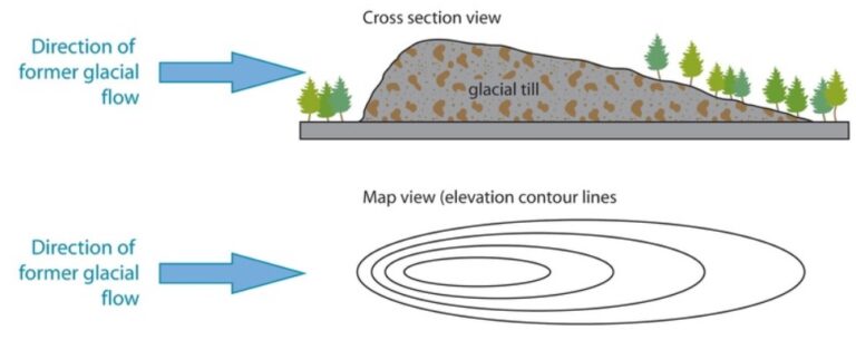
Drumlins
These hills are formed when a glacier pushes up debris into an egg-shaped mound. Some examples include Bunker Hill, the Boston Harbor islands, and the drumlin that gives Drumlin Farm in Lincoln its name. Groton has 42 drumlins including Gibbet Hill, Chestnut Hill (the highest point in Groton at 516 feet), Indian Hill, and Scarlet Hill! Such a collection of drumlins is called a “swarm of drumlins” and is quite rare in the world. Drumlins can be 0.2 mi to 0.5 mi long and 75 ft to 250 ft high. They are oriented in the north-south direction and one end (usually the north side) is steep while the other end is more gradually sloped.
Eskers
As glaciers recede, rivers of meltwater course through cracks in the glacier, leaving behind snaking trails of gravel and other streambed material deposited by the flowing water. These long winding ridges that are typically 20 to 75 feet high are called eskers. They can be anywhere from a hundred feet to a half mile in length. Walk along eskers at Wharton Plantation, Gamlin Crystal Springs, Groton Hills, and Casella Preserve.
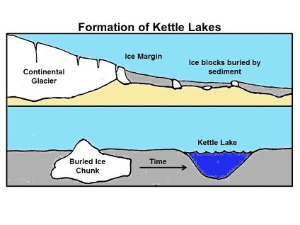
Kettle Ponds and Holes
When giant blocks of ice fall off glaciers and become partly buried by sediment carried by glacial outwash, they form kettle ponds when the ice finally melts. The famous Walden Pond in Concord is a kettle pond. Kettle ponds can be found in Groton Town Forest’s Ames Pond, Wharton Plantation, Wattles Pond, Baddacook Pond, Duck Pond, and others. If the bottom of the hole is above the water table and thus stays dry, it is called a kettle hole, examples of which are common in the Groton Town Forest. Because of the way they are formed, most are circular and have an elevated “rim” of soil all around them.